
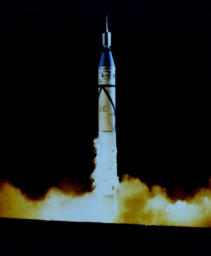
This photo shows the launch of Explorer 1 from Cape Canaveral, Fla., on Jan. 31, 1958. Explorer 1 is the small section on top of the large Jupiter-C rocket that blasted it into
orbit. With the launch of Explorer 1, the United States officially entered the space age.
Image credit: NASA
Satellites are a part of our everyday life. We use global positioning system (GPS) satellites to help us find directions. Satellite television and telephones bring us entertainment, and they connect people all over the world. Weather satellites help us
create forecasts, and if there’s a disaster—such as a hurricane or a large fire—they can help track what’s happening. Then, communication satellites can help us warn people in harm’s way.
There are many different types of satellites. Some are smaller than a shoebox, while others are bigger than a school bus. In all, there are more than 1,000 satellites orbiting Earth. With that many always around, it can be easy to take them for granted. However, we haven’t always had these helpful eyes in the sky.
The United States launched its first satellite on Jan. 31, 1958. It was called Explorer 1, and it weighed in at only about 30 pounds. This little satellite carried America’s first scientific instruments into space: temperature sensors, a microphone, radiation detectors and more.
Explorer 1 sent back data for four months, but remained in orbit for more than 10 years. This small, relatively simple satellite kicked off the American space age. Now, just 60 years later, we depend on satellites every day. Through these satellites, scientists have learned all sorts of things about our planet.
For example, we can now use satellites to measure the height of the land and sea with instruments called altimeters. Altimeters bounce a microwave or laser pulse off Earth and measure how long it takes to come back. Since the speed of light is known very accurately, scientists can use that measurement to calculate the height of a mountain, for
example, or the changing levels of Earth’s seas.
Satellites also help us to study Earth’s atmosphere. The atmosphere is made up of layers of gases that surround Earth. Before satellites, we had very little information about these layers. However, with satellites’ view from space, NASA scientists can study how the atmosphere’s layers interact with light. This tells us which gases are in the air and how
much of each gas can be found in the atmosphere. Satellites also help us learn about the clouds and small particles in the atmosphere, too.
When there’s an earthquake, we can use radar in satellites to figure out how much Earth has moved during a quake. In fact, satellites allow NASA scientists to observe all kinds of changes in Earth over months, years or even decades.
Satellites have also allowed us—for the first time in civilization—to have pictures of our home planet from space. Earth is big, so to take a picture of the whole thing, you need to be far away. Apollo 17 astronauts took the first photo of the whole Earth in 1972. Today, we’re able to capture new pictures of our planet many times every day.
Today, many satellites are buzzing around Earth, and each one plays an important part in how we understand our planet and live life here. These satellite explorers are possible because of what we learned from our first voyage into space with Explorer 1—and the decades of hard work and scientific advances since then.
To learn more about satellites, including where they go when they die, check out NASA Space Place
![]()
