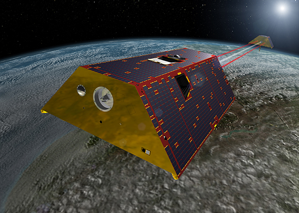
An artist’s rendering of the twin GRACE-FO spacecraft in orbit around Earth. Credit: NASA
As far as we know, water is essential for every form of life. It’s a simple molecule, and we know a lot about it. Water has two hydrogen atoms and one oxygen atom. It boils at 212° Fahrenheit (100° Celsius) and freezes at 32° Fahrenheit (0° Celsius). The Earth’s surface is more than 70 percent covered in water.
On our planet, we find water at every stage: liquid, solid (ice), and gas (steam and vapor). Our bodies are mostly water. We use it to drink, bathe, clean, grow crops, make energy, and more. With everything it does, measuring where the water on Earth is, and how it moves, is no easy task.
The world’s oceans, lakes, rivers and streams are water. However, there’s also water frozen in the ice caps, glaciers, and icebergs. There’s water held in the tiny spaces between rocks and soils deep underground. With so much water all over the planet—including some of it hidden where we can’t see—NASA scientists have to get creative to study it all. One way that NASA will measure where all that water is and how it moves, is by launching a set of spacecraft this spring called GRACE-FO.
GRACE-FO stands for the “Gravity Recovery and Climate Experiment Follow-on.” “Follow-on” means it’s the second satellite mission like this—a follow-up to the original GRACE mission. GRACE-FO will use two satellites. One satellite will be about 137 miles (220 km) behind the other as they orbit the Earth. As the satellites move, the gravity of the Earth will pull on them.
Gravity isn’t the same everywhere on Earth. Areas with more mass—like big mountains—have a stronger gravitational pull than areas with less mass. When the GRACE-FO satellites fly towards an area with stronger gravitational pull, the first satellite will be pulled a little faster. When the second GRACE-FO satellite reaches the stronger gravity area, it will be pulled faster, and catch up.
Scientists combine this distance between the two satellites with lots of other information to create a map of Earth’s gravity field each month. The changes in that map will tell them how land and water move on our planet. For example, a melting glacier will have less water, and so less mass, as it melts. Less mass means less gravitational pull, so the GRACE-FO satellites will have less distance between them. That data can be used to help scientists figure out if the glacier is melting.
GRACE-FO will also be able to look at how Earth’s overall weather changes from year to year. For example, the satellite can monitor certain regions to help us figure out how severe a drought is. These satellites will help us keep track of one of the most important things to all life on this planet: water.
You can learn more about our planet’s most important molecule here: https://spaceplace.nasa.gov/water


