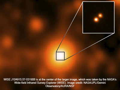
NASA’s Wide-field Infrared Survey Explorer (WISE) has discovered a pair of stars that has taken over the title for the third-closest star system to the sun. The duo is the closest star system discovered since 1916.
Both stars in the new binary system are “brown dwarfs,” which are stars that are too small in mass to ever become hot enough to ignite hydrogen fusion. As a result, they are very cool and dim, resembling a giant planet like Jupiter more than a bright star like the sun.
“The distance to this brown dwarf pair is 6.5 light-years — so close that Earth’s television transmissions from 2006 are now arriving there,” said Kevin Luhman, an associate professor of astronomy and astrophysics at Penn State University, University Park, Pa., and a researcher in Penn State’s Center for Exoplanets and Habitable Worlds.
“It will be an excellent hunting ground for planets because the system is very close to Earth, which makes it a lot easier to see any planets orbiting either of the brown dwarfs.”
The results will be published in the Astrophysical Journal Letters.
The star system is named “WISE J104915.57-531906” because it was discovered in an infrared map of the entire sky obtained by WISE. It is only slightly farther away than the second-closest star, Barnard’s star, which was discovered 6 light-years from the sun in 1916. The closest star system consists of: Alpha Centauri, found to be a neighbor of the sun in 1839 at 4.4 light-years away, and the fainter Proxima Centauri, discovered in 1917 at 4.2 light-years.
Read Full Story Here


