

Jun 13
Hubble’s bubble lights up the interstellar rubble
By Ethan Siegel
When isolated stars like our Sun reach the end of their lives, they’re expected to blow off their outer layers in a roughly spherical configuration: a planetary nebula. But the most spectacular bubbles don’t come from gas-and-plasma getting expelled into otherwise empty space, but from young, hot stars whose radiation pushes against the gaseous nebulae in which they were born. While most of our Sun’s energy is found in the visible part of the spectrum, more massive stars burn at hotter temperatures, producing more ionizing, ultraviolet light, and also at higher luminosities. A star some 40-45 times the mass of the Sun, for example, might emits energy at a rate hundreds of thousands of times as great as our own star.
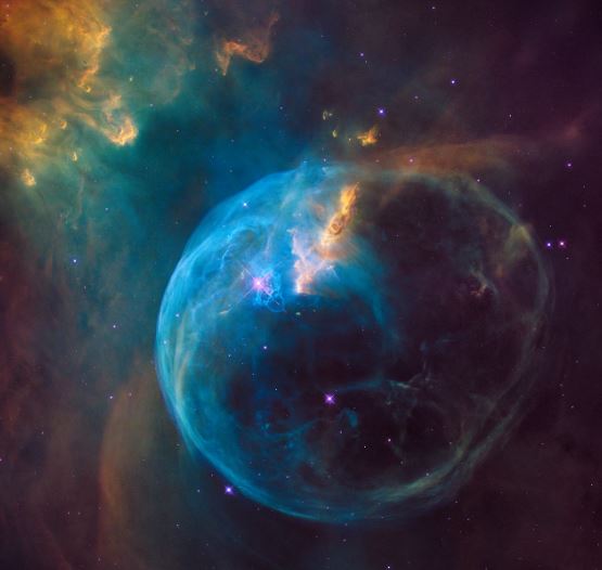
The Bubble Nebula, discovered in 1787 by William Herschel, is perhaps the classic example of this phenomenon. At a distance of 7,100 light years away in the constellation of Cassiopeia, a molecular gas cloud is actively forming stars, including the massive O-class star BD+60 2522, which itself is a magnitude +8.7 star despite its great distance and its presence in a dusty region of space. Shining with a temperature of 37,500 K and a luminosity nearly 400,000 times that of our Sun, it ionizes and evaporates off all the molecular material within a sphere 7 light years in diameter. The bubble structure itself, when viewed from a dark sky location, can be seen through an amateur telescope with an aperture as small as 8″ (20 cm).
As viewed by Hubble, the thickness of the bubble wall is both apparent and spectacular. A star as massive as the one creating this bubble emits stellar winds at approximately 1700 km/s, or 0.6% the speed of light. As those winds slam into the material in the interstellar medium, they push it outwards. The bubble itself appears off-center from the star due to the asymmetry of the surrounding interstellar medium with a greater density of cold gas on the “short” side than on the longer one. The blue color is due to the emission from partially ionized oxygen atoms, while the cooler yellow color highlights the dual presence of hydrogen (red) and nitrogen (green).
The star itself at the core of the nebula is currently fusing helium at its center. It is expected to live only another 10 million years or so before dying in a spectacular Type II supernova explosion.
![]()
Jun 11
Light Pollution Hides Milky Way From 80 Percent Of North Americans
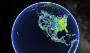
This view of North America as seen in Google Earth shows colored areas that denote levels of light pollution as detailed in the New World Atlas of Artificial Sky Brightness.
Fabio Falchi et al./AAAS
The luminous glow of light pollution prevents nearly 80 percent of people in North America from seeing the Milky Way in the night sky.
That’s according to a new atlas of artificial night sky brightness that found our home galaxy is now hidden from more than one-third of humanity.
While there are countries where the majority of people still live under pristine, ink-black sky conditions — places such as Chad, Central African Republic and Madagascar — more than 99 percent of the people living in the U.S. and Europe look up and see light-polluted skies.
The country with the worst light-pollution is Singapore, where researchers found that “the entire population lives under skies so bright that the eye cannot fully dark-adapt to night vision.”
Other countries with large percentages of people living under skies this bright include Qatar, Kuwait and the United Arab Emirates.
