By Ethan Siegel
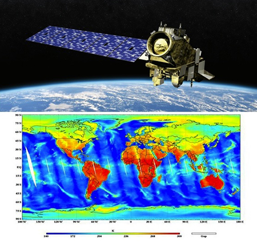
Images credit: an artist’s concept of the JPSS-2 Satellite for NOAA and NASA by Orbital ATK (top); complete temperature map of the world from NOAA’s National Weather Service (bottom).
If you want to collect data with a variety of instruments over an entire planet as quickly as possible, there are two trade-offs you have to consider: how far away you are from the world in question, and what orientation and direction you choose to orbit it. For a single satellite, the best of all worlds comes from a low-Earth polar orbit, which does all of the following:
- orbits the Earth very quickly: once every 101 minutes,
- is close enough at 824 km high to take incredibly high-resolution imagery,
- has five separate instruments each probing various weather and climate phenomena,
- and is capable of obtaining full-planet coverage every 12 hours.
The type of data this new satellite – the Joint Polar Satellite System-1 (JPSS-1) — will take will be essential to extreme weather prediction and in early warning systems, which could have severely mitigated the impact of natural disasters like Hurricane Katrina. Each of the five instruments on board are fundamentally different and complementary to one another. They are:
- The Cross-track Infrared Sounder (CrIS), which will measure the 3D structure of the atmosphere, water vapor and temperature in over 1,000 infrared spectral channels. This instrument is vital for weather forecasting up to seven days in advance of major weather events.
- The Advanced Technology Microwave Sounder (ATMS), which assists CrIS by adding 22 microwave channels to improve temperature and moisture readings down to 1 Kelvin accuracy for tropospheric layers.
- The Visible Infrared Imaging Radiometer Suite (VIIRS) instrument, which takes visible and infrared pictures at a resolution of just 400 meters (1312 feet), enables us to track not just weather patterns but fires, sea temperatures, nighttime light pollution as well as ocean-color observations.
- The Ozone Mapping and Profiler Suite (OMPS), which measures how the ozone concentration varies with altitude and in time over every location on Earth’s surface. This instrument is a vital tool for understanding how effectively ultraviolet light penetrates the atmosphere.
- Finally, the Clouds and the Earth’s Radiant System (CERES) will help understand the effect of clouds on Earth’s energy balance, presently one of the largest sources of uncertainty in climate modeling.
The JPSS-1 satellite is a sophisticated weather monitoring tool, and paves the way for its’ sister satellites JPSS-2, 3 and 4. It promises to not only provide early and detailed warnings for disasters like hurricanes, volcanoes and storms, but for longer-term effects like droughts and climate changes. Emergency responders, airline pilots, cargo ships, farmers and coastal residents all rely on NOAA and the National Weather Service for informative short-and-long-term data. The JPSS constellation of satellites will extend and enhance our monitoring capabilities far into the future.
![]()